Driving
The Eco-Tour
 The
West Block of Grasslands National Park has a single drivable gravel
road. That road traverses the current holdings of the park from Highway
18 in the north and returns to Val Marie via some other gravel roads. The
West Block of Grasslands National Park has a single drivable gravel
road. That road traverses the current holdings of the park from Highway
18 in the north and returns to Val Marie via some other gravel roads.
A very crude map of the road is available from the Val Marie visitor's
centre. A short interpretation guide for $2.00 is also available from
the Visitor's Centre. Help support the park and buy the guide.
Always drive with a full-tank of gas. The eco-tour is entered from
a well-marked access road just east of Val Marie on Highway 18. The
road then proceeds through the park with roadside pull-outs throughout
the park. The pull-outs correspond to the articles in the Eco-tour guide.
You are free to stop anywhere along the road and walk around. A number
of day hikes featured in the Guide to the Hiking Routes of Grasslands
National Park have their trailheads starting from this road. Even
if you don't want to walk a full day, take some time to walk across
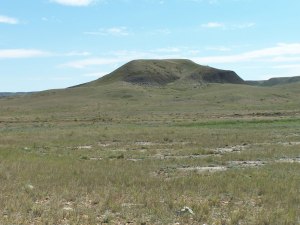
the grasslands and feel yourself swallowed up by the immense and overwhelming
scenery. But don't be so overwhelmed that you forget to take a bottle
of water on your walk. Stop #2 has a bison rubbing stone and some teepee
rings a short, easy, 100 m walk from the road.
 Just
across the Frenchman River, Belza's ranch offers the only vehicle campsite
within the west block. Here you can park your RV or tent trailer for
the night after making arrangements at the visitor's centre. For camping
rules in the park, visit the park's web
site or my camping recommendations.
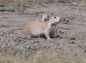
Farther on are the only Black-tail Prairie Dog colonies in Canada and
the rare Burrowing Owl. What Canadians usually call Prairie Dogs are
really Richardson Ground Squirrels or Gophers. Here is about the only
place where you can find the real thing. Just
across the Frenchman River, Belza's ranch offers the only vehicle campsite
within the west block. Here you can park your RV or tent trailer for
the night after making arrangements at the visitor's centre. For camping
rules in the park, visit the park's web
site or my camping recommendations.
Farther on are the only Black-tail Prairie Dog colonies in Canada and
the rare Burrowing Owl. What Canadians usually call Prairie Dogs are
really Richardson Ground Squirrels or Gophers. Here is about the only
place where you can find the real thing.
 The
map lists a number of other "Bladed trails", "Prairie
Trails", and Private Access roads. Don't attempt these with anything
less than a mid-sized car. There are large rocks with will play tag
with your oil pan. There is also a road on the map that extends eastward
from Highway #18 as the highway curves north and should cut across the
north side of the park. This road just doesn't exist. We tried to take
it back from Gillespie's ranch and the Molestead coulee. It just headed
north across a rock-laden, dirt path and through about 8 different cattle
fences until we found a rancher who invited us to follow him to Mankota. The
map lists a number of other "Bladed trails", "Prairie
Trails", and Private Access roads. Don't attempt these with anything
less than a mid-sized car. There are large rocks with will play tag
with your oil pan. There is also a road on the map that extends eastward
from Highway #18 as the highway curves north and should cut across the
north side of the park. This road just doesn't exist. We tried to take
it back from Gillespie's ranch and the Molestead coulee. It just headed
north across a rock-laden, dirt path and through about 8 different cattle
fences until we found a rancher who invited us to follow him to Mankota.
Back to the Grasslands National
Park Visit
| 


